In the Middle Ages the important coastal road from Acre and Haifa to Jerusalem ran through a narrow, probably man made passage in the sandstone ridge that runs parallel to the coast line directly to the east of Atlit peninsula. In primary sources this passage is called amongst others Petra Incisa ("carved rock") or Districtum/Destrictum, Destroit or Détroit ("strait") . The setting made the site an ideal location for robbers to ambush pilgrims and other travelers. As even King Baldwin I of Jerusalem discovered in 1103, when he was wounded by robbers in the area. What is the history of this remarkable place and what have the Templars to do with it?
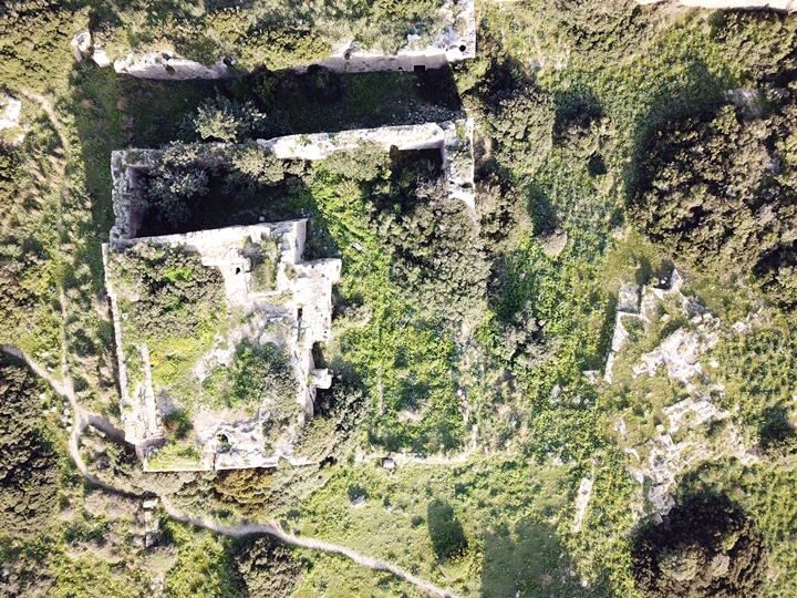
Ar present there are at the site ruins of a medieval tower fortress, near present day Atlit, Israel. The castle's podium, stables and moat, are cut into the sandstone rock. It is known as Le Destroit, Districtum, Horvat Qarta, Khirbet Carta, or Khirbat Dustrey.
Boaz (2006) argues that the date of construction of the Destroit tower presumably was in the first half of the
twelfth century. Friedman
dates the construction to 1118 and claims it was built by the
Templars and used as a police station or fort.
After studying and combining many primary sources, Gilet (2019) concludes that around 1115, at the request of King Baldwin I and probably the Patriarch of Jerusalem, around thirty knights (with their servants, so a substantial group) united to participate in the protection of pilgrims. They chose Hugues de Payns as coordinator of operations. De Payns, a middle class noble from Champagne, France, had only recently (1114) arrived in the Holy Land with his patron, Hugues I Count of Champagne. The mission this group was given was to protect the pilgrims at the passage at Atlit, in the Petra Incisa Passage, for a period of three years. For that purpose they constructed Le Destroit Keep.
The knights placed themselves under the protection of the Patriarch and the Augustinian Canons of the Holy Sepulchre, adopting their rule of life and living in poverty, chastity and obedience. Their mission being a success, they got involved in defending the Latin States in a more general way. Around 1118-1120, possibly after recognition at the Council of Nablus, these 'proto-templars' moved to Jerusalem, leaving a garrison at the Destroit Keep. In Jerusalem the group developed further into the Poor Fellow-Soldiers of Christ and of the Temple of Solomon, the Knights Templar. According to this timeline reconstruction Le Destroit was the first Templar guard post in the Holy Land.
During all of the 12th century, Destroit Keep remained in function. In 1191 the tower fortress served as
campsite to King Richard I of England following the recapture
of Acre. However, when in 1218 the huge Castrum Perigrinorum (Château Pèlerin) was
completed on the nearby Atlit peninsula, Le Destroit lost its purpose. It was dismantled by the Crusaders so that
it couldn't be used by the Muslim enemy as a staging ground for an
attack on the new castle.
Boaz (2006) explains that square and rectangular keeps were one of the most common types of castles in the Crusader states. Some 75 towers are known from archaeological remains and a large number of additional keeps is recorded in historical sources in the Kingdom of Jerusalem alone. This type of castle appears to have originated in the West. A number of these small towers in the Latin East were possessed by the Military Orders. The Templars built towers chiefly to protect pilgrims travelling on the roads, while other towers were built or purchased to serve as centres for the administration of rural properties.
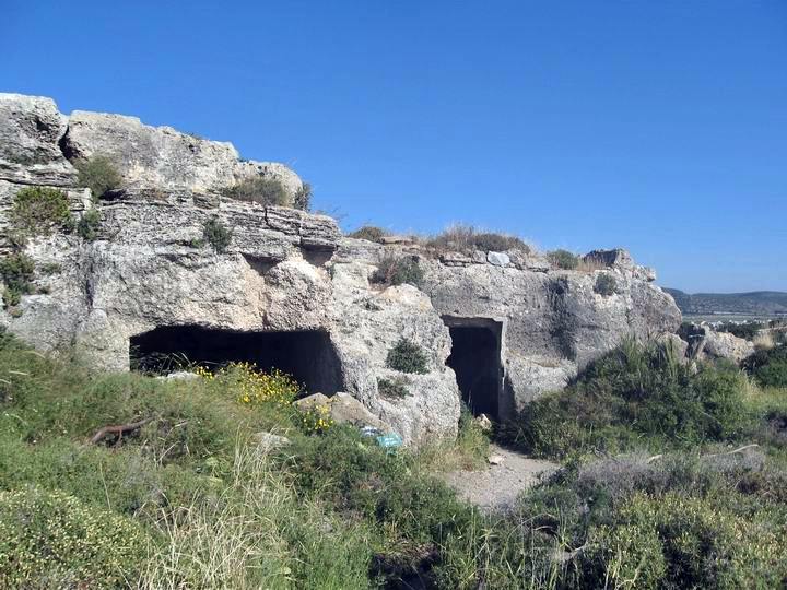
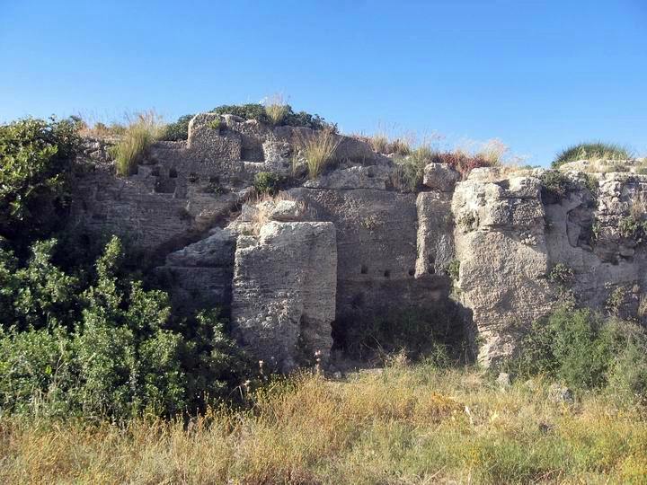
sources: Wikipedia on setting of Le Destroit; description of the tower quoted from Archeology of the Military Orders bij Adrian Boaz (2006); early dating sequence from Hughes de Payns en Orient by François Gilet (2019) p 68. Illustration top: Tour de Destroits seen from the air; Middle: detail of the south side of the post. The small holes cut into the rock were used to hold the wood poles that were part of a roof. The large diagonal groove was part of the water cistern system, so the winter rains were collected from the rooftop and used to supply water for the guards throughout the year. bottom: Rock cut stables at Destroit castle; source all illustrations: www.biblewalks.com. Aditional information on Destroit including pictures can be found here.
No comments:
Post a Comment